We've had a bit of wet and frosty weather lately here in central Oklahoma (US) but this morning is beautiful and I wanted to show some photos of the garden.
One of the things I did over the summer was to block off an area around my Bradford pear to create a partial shade garden. I've scattered quite a few different sorts of seeds here and the parsley seems to be loving it here.
Parsley makes a nice ground cover, although some people think it looks a bit weedy when it flowers. But all parts are edible, and the flower stalks are easy enough to remove if you decide you don't like the look of them. The flowers make a nice addition to floral arrangements.
On the other side of the yard, over by my front porch pond's waterfall, the mint is still going strong after two hard freezes:
Over in the bottom left is garlic, which stays green here all winter, even under snow.
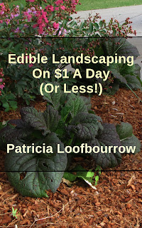
The kale is having a great time through all this, and is one of the highlights of the front garden right now!
I love these colorful kale plants. They're really tasty too!
If you notice, there's a bit of lettuce starting up in that last photo.
Here are some other salad greens starting up too.
I scattered the same seeds all over both of these garden plots, and it's interesting to see where certain ones like to grow. For some reason, arugula likes the area by the rose bush and red yuccas, in the front of the garage. It's still blooming!
I wanted to also tell you some good news: I got an avocado seed to sprout! I have been trying to get one to sprout for several years now, so I'm really excited about this.
I'm pretty sure this wouldn't survive the winter outdoors, but so far it's a beautiful container plant! I plan to re-pot it and put it in the garage with my banana and pineapple plants to overwinter.
What's in the plans for next year? I'd like to do some cover cropping with clover in the front garden plots, and do more plantings in the back yard along the chain link fence. I have quite a bit of corn seed, and it might make a nice privacy screen for the summer. I also have some amaranth I'd like to plant and see how it does here.
How's your garden?
You can share your photos here!